![]() Cartographer’s Story #16, by Herwig G. Schutzler
Cartographer’s Story #16, by Herwig G. Schutzler
Cartography. Is it a Science? Is it an artistic profession? Can anybody learn it? Cartography is an ancient profession, evidenced by Babylonian clay tablets, among the first maps produced by man, which portrayed real estate holdings so the king could tax the people! Oh well, why not? We also know, that the maps created by the Cartographers of the world’s explorers were guarded like gold by their owners, assuring them their holdings of discovered land and the routes leading to them.
In my young years I loved to read books about James Cook, Marco Polo or Sven Hedin. I enrolled into the very old German cartographic firm Justus Perthes in Gotha/Germany and my teacher was one of Germany’s Master Cartographers, a title that had to be earned with long years of work, studies and experiences.
Years later, working at the internationally known Institute of Applied Geodesy in Frankfurt Germany, I had a chance to be introduced to the art of creating shaded terrain reliefs for topographic maps. My teacher was a student of Prof. Imhof of Switzerland. We soon discovered that I had a talent of “seeing” the terrain of any geographic area, by just looking at either the elevation contour lines or the hydrographic net.
Below is one of my first attempts of four-color terrain art. It is the south-western region of the Chiem See in Austria.
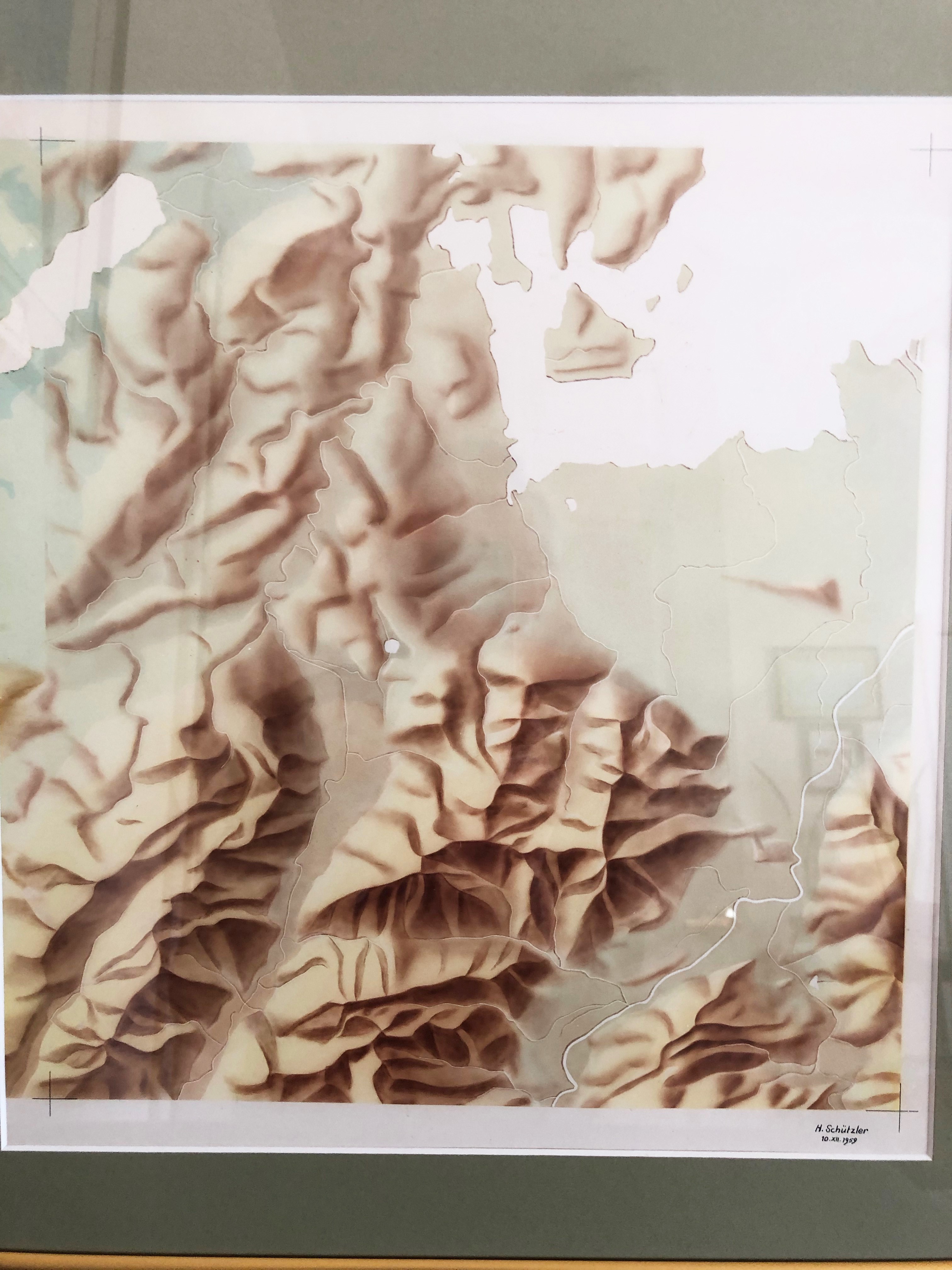
Looking at terrain map art gives one a feeling of being there. Being able to create the terrain was, to me, a fulfillment of geographic understanding. Since you have to study the general Geography of a chosen region, you become spatially and spiritually attached to that region; it is almost like being at home there.
Being able to create the terrain was, to me, a fulfillment of geographic understanding…you become spatially and spiritually attached to that region; it is almost like being at home there.
Which brings me back to my question of Cartography as a science. In my days of cartographic schooling and training, both in Communist East Germany and in what was at one time West Germany, we studied Mathematics, Geometry, Geodetics, Geology, Physical Geography, Cartography, Graphic Arts and of course associated courses in languages and general knowledge. That took about four years and resulted in me being called a Cartographer.
With that knowledge, and my ability of creating terrain art, I was able to go on a career in many fields of map making, both in government activities and the private sector. I loved Cartography, I loved Geography, and I was always able to apply this deep involvement to my total satisfaction.
I worked on East German military maps, I worked on US Army maps in Germany, assuming responsibilities on a very wide range of topographic maps. In the US, working at first for Rand McNally in Chicago, I started to get involved in creating maps for American school text books. For a number of years I had my own cartographic company, creating maps for the educational school book market in the US and also working on maps for the US Air Force. Then I joined R.R. Donnelley & Sons in Chicago and we build up a very large, very successful custom cartography unit. This unit was bought by a financial interest group in California and out of that process, over a number of years, evolved MapQuest.
I “retired” in 2002 from the process of creating or managing the developments of maps, but have stayed in touch with many people that I had met during all these great years.
It is my sincere hope that our informative profession, important for all mankind, will be furthered and maintained with the same enthusiasm as most of us always had.
Herwig G. Schutzler
Lititz, PA., 2019
