 Cartographer’s Story #15, by Alex Fries
Around my friends and colleagues, I’m very much known as “the guy who loves Alabama.” Every chance I get, I stand up for all of the good things that the state has to offer—though I’m never one to back down from admonishing its shortcomings (which arguably takes more love to do). So it surprises a lot of those same people when I tell them, “No, I did not always love Alabama the way I do now.”
Quite the opposite, in fact. See, I was born in Sacramento, CA, and then I moved to Germany when I was only one year old, and then there were several shorter stints in places like Belgium, Florida, Arizona, and Maryland along the way. And all of these places seemed infinitely more exciting and interesting than the place that I ended up settling in for the majority of my childhood: Dothan, Alabama, a city at the heart of the state’s Wiregrass Region that is known for peanuts and for being shaped like a circle and for having a lot of chain restaurants. In comparison to all the other places I’d been to, Dothan (and Alabama by extension) seemed stifling: it was too hot, too humid, too flat, and just all around to boring to young me. And as I grew older, my disinterest for Alabama turned into a distaste of what the state wasn’t, and I yearned to leave it behind as soon as I could.
Yet in my senior year of high school, I made a bit of a change in my attitude towards my long-time home. After a new library opened up in downtown Dothan, I made a habit of going to the local history section and reading through books about the history and development of the city I’d taken for granted for so long. The more I learned about the city’s past, the more I came to appreciate it for what it is. So by the time I’d moved to Tuscaloosa to begin attending the University of Alabama, I felt largely amicable towards the “Peanut Capital of the World,” being more than willing to acknowledge the city’s good qualities as well as express my dissatisfactions with the not-so-good.
And as I grew older…I yearned to leave [Alabama] behind as soon as I could.
However, much like other people I met at the university from large cities like Chicago or Atlanta who felt little affinity for the states those cities were in, I too did not feel much pride or love for the state of Alabama as a whole. There were valid reasons for this, I suppose. After all, Dothan and its surroundings comprise but a very small part of the entire state, but the fact was that I didn’t get much exposure to the rest of the state while growing up. So I came to subconsciously attach many of the negative feelings I’d had for my hometown to the state as a whole, despite having been taught since grade school that Alabama was in fact a very physically and culturally diverse state. Though I’d been able to shake off my completely negative feelings for my hometown, it would still take some time before I came around towards appreciating the rest of the state to the same extent.
This is where cartography enters into the story.
Like other people in this field, I too had grown up loving maps and learning about the world, which largely informed my decision to enter my undergraduate studies as a geography major. But I didn’t really know what I wanted to do with a geography degree beyond that. However, I was steered into the direction of cartography through three different events:
- I stumbled across Anton Thomas’s map of North America in early 2015. I found the map to be beautiful and breathtaking—yet I was left a little sad that his depiction of Alabama hadn’t included my hometown, despite it fitting into his criteria. So I sent him a long email asking him if he might be willing to put Dothan on the map—to which he responded that he would! From all this, I discovered cartography to be a completely viable outlet for my interest in geography that was worth considering, one that seemed both fun and interesting. (And yes, Anton did eventually add Dothan to his map).
- In late 2015, I was offered the chance to work in UA’s Cartography Lab thanks to my good performance in a class taught by the lab supervisor. I eventually reached a point where I began to make maps of my own, many of which focused on Alabama. The time and research spent in making these maps of Alabama did much to undo many of the subconscious beliefs and misconceptions I held about the state and helped give me a greater appreciation for it that was no longer confined to just my hometown.
- In late 2016, sparked by a desire to seek out inspiration, I googled “cartography blogs” and came across Daniel Huffman’s blog somethingaboutmaps. I was immediately blown away by what I saw on the blog, and I did whatever I could to adopt as many of his various visualization techniques as I could into my own work. His overall approach to mapping also served as the final confirmation that cartography was absolutely something that I wanted to pursue as an actual career.
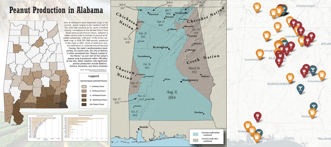
More time went by, and in turn I made more maps and I began to improve as a cartographer (I think). But none of the maps quite lived up to a map I’d been hoping to make for some time by the time 2018 rolled around: a landform/land cover map in the vein of Daniel’s map of Michigan, which I had been immediately drawn to for its undeniable beauty and clarity. An opportunity arose, however, when my remote sensing instructor gave me permission to make such a map for my semester project. And I knew exactly what I would make a map of: Alabama. By now, it was the place I knew better than anywhere else. And I had come around to realizing that the state was so much more interesting than the dull, boring place I had made it out to be as a kid—and I wanted to make a map that would let other people see Alabama the way I now did.
In the beginning, it looked as though I was way over my head in making this map. I’d never attempted something like it, and so I very likely spent at least 50 hours just on getting the basemap to look right. I then probably spent another 50 hours labeling it, making sure to capture every major and minor natural feature alike that I could cram onto the map. It quickly turned into a project that pushed me to go into the office at 8:00 pm on Saturday nights and work on it until 3:00 the next morning. But the crazy thing about my new, self-induced lack of sleep was that I did it all because I wanted to! The map became something that I simply loved working on, and I realized on one of those late nights that I ultimately loved working on that map so much because I loved its subject matter—because I loved Alabama. And this map was becoming my way of letting the rest of the world know that I loved and cherished this place, the so-called “Heart of Dixie,” in spite of all of its many flaws and its poor reputation. Because I realized in the process of making this map that even a place like Alabama is worth going through the trouble of elevating the good that can be found in it in order to redeem it. Though I had long dismissed the state for everything I saw wrong about it, through time and exposure Alabama had certainly been able to redeem itself in my mind, and I thus made it my mission to do this redemption its proper justice through my map. I aimed to make the map showcase every mountain, valley, river, swamp, waterfall, plain, natural bridge, and impact crater with a level of clarity and detail that would allow for Alabama’s story to be told in the way I felt it deserved to be told. It took many, many months of grueling work to reach a point where I could consider this goal accomplished, but eventually it did reach that point—and just in time for me to turn it in for my project grade!
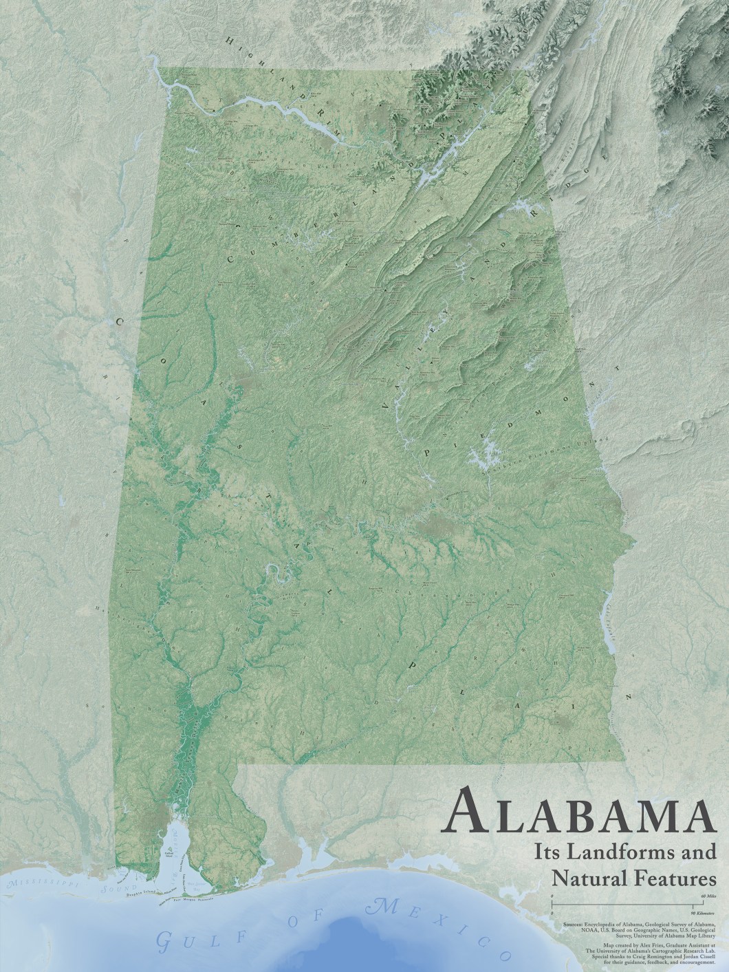
If there’s a climax to be found in this long-winded story, it came when I finally got the chance to present the map to an audience of fellow cartographers at NACIS 2018. I’d first heard about the organization through Daniel Huffman’s blog, and I’d since made it a personal goal to someday attend a NACIS meeting, so when the opportunity arose to take a trip up to Norfolk, Virginia, I decided that I would bring the map of Alabama along with me. For all the boisterous passion I felt for the map, however, I was in fact deathly afraid of how it might be received at the conference. I wasn’t completely naïve: this was a map of Alabama after all, a place that doesn’t exactly have a good reputation beyond its borders. I was afraid that, for its subject matter alone, the map would be shunned and ignored. However, what I found instead was nothing short of incredible: my fellow cartographers seemed to show a deep and genuine interest in the map. Few, if any at all, admonished the map for its subject matter, and any critiques of it simply pertained to how I might be able to improve my cartography in the future. And it was eye-opening to see my map pique a newfound interest for the state in many of the people I met, with some acknowledging that it had taught them a great deal about a state they knew relatively little about, and others expressing that they wanted to someday visit Alabama because of my map! The fact that the map ended up being the winner of that year’s Student Design Competition was really just a consolation prize in the end—as cliché as it may sound, I truly do consider the incredible experience I had meeting and befriending cartographers from around the world to be the ultimate reward of my first NACIS experience.
It was eye-opening to see my map pique a newfound interest for the state in many of the people I met…
My newfound love for Alabama has hardly wavered since that fateful trip to Norfolk. Indeed, I do everything I can to learn more about my state now, which in turn has only strengthened my passion for it and my resolve to make it the best place that it can be. Don’t get me wrong: I remain very cognizant of the many ways in which Alabama could improve. But I also stand by my newfound belief that a place like Alabama deserves to be praised wherever praise is due, just like the idyllic places of my early childhood that I so often pitted Alabama against. And more than that, I’ve taken it on as a mission of sorts to recognize, cherish, and celebrate all of the good that the state can offer to the rest of the world through cartography—after all, how can a place ever hope to better itself if those who call it home aren’t willing to first uncover the things that make it worth redeeming? This, of course, would include me, because I love Alabama—it is my home, after all—and I have cartography to thank for that.
