What a hare-brained idea, riding a bicycle from Vancouver, Canada to the Yukon Territory. It leapt into my head in 1998, the idea of taking a trip that was self-propelled, right from my back door. I have always been a cyclist –both commuter and traveler– and I enjoy that pace of traversing the countryside. I was mature student in the visual arts at Simon Fraser University, and I pitched the trip as an idea for a directed studies course. My professor, Greg Snider, and I tossed about ways of documenting the voyage. He liked the idea of collecting water samples and rocks en route; I panicked, imagining pedaling all my camping gear plus panniers full of rocks up steep roads. We finally agreed on a project that would fit in a plastic recipe box.

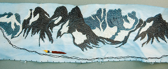
The Bike Trip Spool is a strip of cloth 10cm wide and 23 meters long. I rolled it up on a chopstick. Before my departure, I marked a centimeter for each kilometer I intended to ride. After each day’s effort, I counted off how many kilometers I had covered and drew the geography as I remembered it, on either side of two thin wavy lines representing my tire tracks. After the trip, I embroidered parts of it. It is a kind of “strip map”, like narrow maps that are lined up in a rectangular map format. The road travels up to the top of the first strip and continues at the bottom of the next one, and so on, focusing on what is immediately on either side of the road. The Spool is just one long piece. It shows what I encountered and saw around me, nothing farther beyond.


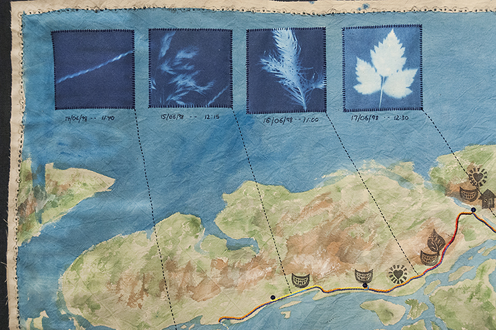
Greg insisted I also record something objectively, so I bought a few packages of solargrams from a children’s science shop. The paper was exposed in the sun (or rain) for 5 minutes and later developed in water in my camping fry pan to make a blue print with white shapes of objects that I had placed on the paper. I did not take a camera on the trip.
The process of making the spool and the blueprints fixed the voyage in my memory better than a camera could. When you take a photo, you press a button. When you draw, you have to repeatedly look at something, or concentrate to recall the details of what happened. As I drew on the cloth spool, I also had to consider where to place events sequentially along the allotted centimeters, incorporating time into the geography. I remember exposing each solargram on a particular place and day: a chain on the ferry ride, gravel from the road, foxtail barley and aspen leaves as I got farther north.
Friends outfitted me with bear spray and snacks, my mother gave me money to stay in a hotel at least once, kids and spouse gave hugs. The landscape, documented on the spool, included animal encounters, weather, rivers, mountains, other campers and memorable fodder. I stopped on bridges to watch rivers, cursed the long stretches of washboard gravel, noticed the change in flora, and hung my food bag from a tree branch at night to discourage bears. I arrived in Atlin, the northernmost town in B.C. some 19 days later.
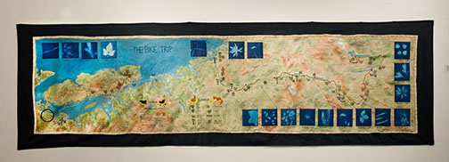
Once I returned home, I began to embroider the spool the way memory embellishes some things and neglects others. For example, I clearly remember the Seven Sisters Mountains near Hazelton but can’t recall anything but gravel around the roadwork on the Alaska Highway. The strip began to change, just as maps are often subject to revision. Tellingly, it no longer fits into the box in which it had traveled. I started to work on a larger, rectangular fabric map to document some other aspects of the trip: the quality/steepness of the road, my mood. But most importantly, I wanted to acknowledge the many kindnesses people offered me. Perhaps a woman in her mid-40s is not perceived as threatening –all sorts of people talked to me. I came up with symbols for happy conversation, offers of lodging, food, tools, even a canoe ride. At first, I planned to trace the land from a projection, but realized it wasn’t important to be geographically accurate. I drew out a rough map but priority was given to indicating the wonderful generosity of strangers. I transferred the solargrams onto cloth and sewed them onto the map with lines connecting to where they had been exposed. These, too, remind me of specific moments and mental states: from WTF am I doing to the sheer euphoria of moving through a grand landscape. I printed a border onto the fabric with a piece of bicycle chain. The resulting two documents are odd yet personally and artistically valuable to me.

The process of voyaging, documenting and embellishing has surfaced in subsequent work. I cherish how this mapping process preserved my memories of the adventure. When I exhibit it, viewers walk the suspended length of the spool. They may not be familiar with the places or events but the work becomes an experience for them as they pass mountains, rivers, bears, pieces of pie, butterflies and moose in a bog. The project reinforces my perception that a map is the ultimate narrative vehicle as it incorporates the past, present, and future –including my hope that I will pass that way again.
