Cartographer’s Story #5, by Ken Field
I have Cartographic Identity Disorder. It’s characterised by multiple identities; dissociated personalities that control what I do and how I do it. The problem is I don’t know what to call what I actually do…but then again, I don’t know that I ever did know and that might be the first step to understanding the problem. I have never been a cartographer but much of what I have done during my life and to earn money to live bears a strong resemblance to the work of a cartographer because I am involved in cartography. My life is intertwined with cartography and a love of maps is more than a passion and a profession – it’s a geolifestyle and one that I fell into and continue to fall for.
Like many who share this affliction, I grew up with a love of Geography and maps. My favorite classes were always Geography and my favorite teachers were the Geographers. Trouble is, when it comes to making a life out of a subject you enjoyed or were good at, the choices are somewhat limited. Unless you moved into teaching there was no such thing as ‘geographer’. I was good at Physics as well…and Biology and both those sciences seem, with hindsight, to have more substance. As a kid I wanted to be a footballer, astronaut, surgeon and even a California Highway Patrol motorcycle officer (too much time spent watching CHiPs). I was never fast enough or skilled enough to be a footballer…I didn’t particularly enjoy Physics (maybe the occasion of our teacher spilling a beaker of liquid Mercury across the classroom affected my disposition) and though I loved Biology I was rubbish at Chemistry so no hope of going to medical school. I also lived nowhere near anywhere where I could be an astronaut or California Highway Patrolman. The school careers advisor’s computer told me I should be a photographer or dental assistant. Hmm…no, so I found a degree course all about maps instead. It was called Cartography….and I found not only that I liked maps but I was reasonably good at it. I could extend my love of geography and maps into a degree…perfect; that’ll delay the inevitable even further!
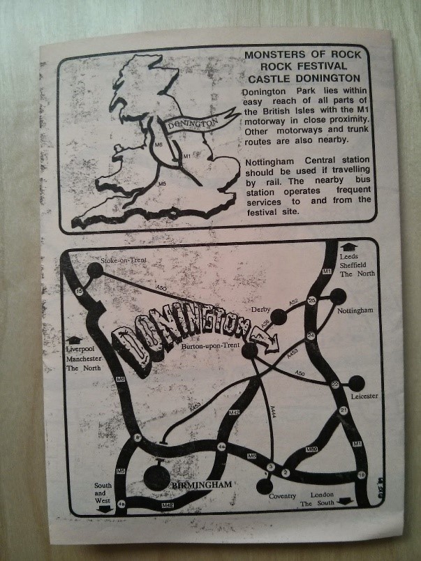
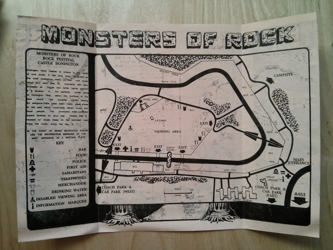
Here’s the first map I made at university. It was a brochure that combined my cartography with some art and my dubious taste in music. I got an A and that pushed me to keep on trying to get As throughout my degree. I didn’t always get As. I failed Intro Geology classes (which is a constant embarrassment as my late father who had passed away a couple of years earlier was an academic and a Geologist, and a fine one at that) and classes on History of modern Cartography (never much use remembering names, dates and places).

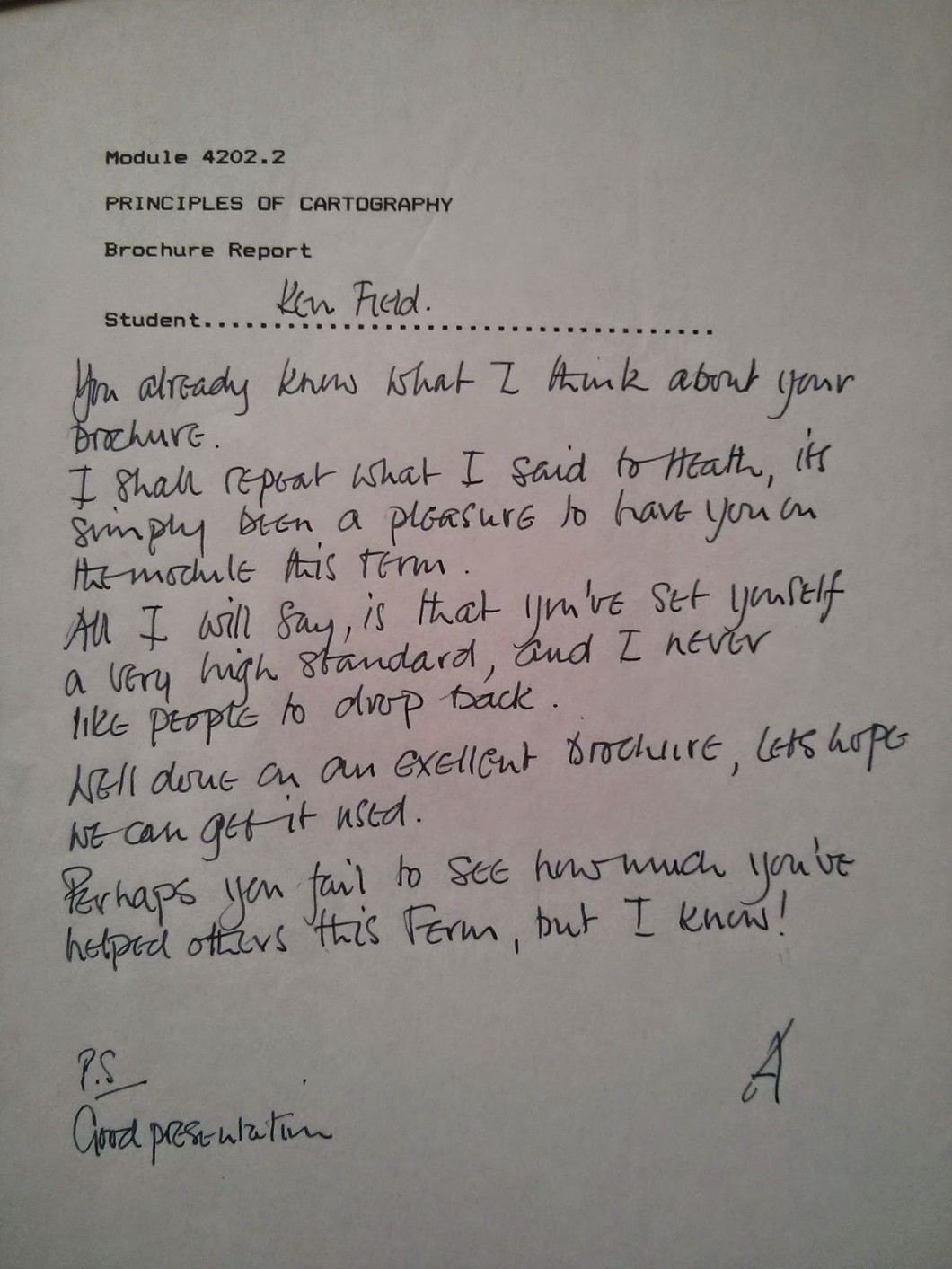
I guess what I am most proud of when I look back at that first map is the comments my Lecturer Roger Anson made – particularly the last line. I had some sort of talent for cartography that he saw and was beginning to nurture. He also saw that perhaps more importantly I had a desire to help others with their own work. When I look back, that was probably the first inklings of a career where I simply try to help others make better maps.
I spent 3 fantastic years in Oxford studying (if that’s what you can call it) cartography. The lecturers were great, mostly because they weren’t really your archetypal lecturers. I met and made some great friends and it turned out I was on a course that seemed to feed the UK cartographic industry. So I went to the British Geological Survey in between my first and second years to spend 3 months being a cartographer in their drawing office. This was 1990. 10 people in a room huddled over their prized personal light tables wielding Rotring pens and getting excited over the nuances of a line drawn with consistent width. The morning coffee break at 10.30 (radio on, car magazine out) lasted 20 minutes. Then lunch (always midday, always the same) and then home. For a couple of days I got to play on an Intergraph workstation with a digital table and a clicky thing that allowed me to turn movements of my right forefinger into bright dots and lines on a computer screen…this seemed quite interesting but it was serious equipment for serious people…not the work experience kid, so it was back to the drawing room for me. I had some of my work published in BGS materials but overall I hated it and vowed NEVER to be a cartographer. It was like battery cage farming where we just drew boring stuff all day. Despite my love of maps I was falling out of love with the idea of being a cartographer. So back to University to finish my studies and then what…
When I graduated in 1991 I’d just taken a new course in something called GIS and I applied to be a researcher at Nene College Northampton to work on GIS related ‘stuff’ (it was poorly conceived as I later found out, because they didn’t really know what it was). I was given the best computer on campus…a magnificent IBM floor standing unit with a massive 4Mb hard drive…enough to install PC ArcInfo and do some GISing. What I slowly began to appreciate at the time is this thing called GIS was rapidly killing professional cartography. Great! It was boring anyway…so what about this new thing. Hmm…two years into the research it became clear I was on my own. No-one else knew anything about GIS. I learnt a lot, self-taught, started a PhD, met some people I later found out were quite big in this GIS thing and then landed a lectureship. Without even planning it I had gone from my love of geography and maps into…teaching. Dammit.
So I spent the next 10 years or so developing courses in GIS and digital cartography at Northampton. We did well. We expanded the course and students loved it. We got fancier clicky things and did more and more. I was the first person in the UK to teach using ArcView 3 and was delighted that I could finally get away from trying to get people to make maps using commands like “display999” and “polygonshades”. Trouble was…it was impossible to make maps anywhere near as good as that boring lot in the BGS drawing office with their slide rules and pens. We were constrained by technology. I completed my PhD; proudly squeezing in 121 maps into my thesis which, by the way, contained a data fudge as several years into processing the data I realized I’d got one tiny thing wrong…I think it’s time I admitted it and I apologise to the residents of Towcester to whom I incorrectly ascribed ‘poor relative access to healthcare’. It seems Mark Monmonier was right after all…my maps lied.
My move into academia was complete. I was a lecturer, course director for Geography degree programmes, I had PhD after my name so I had the academic badge that meant I must be clever (!) and I taught cartography and GIS classes using the currently in vogue tools so I was at the cutting edge of technology. I then had an opportunity to move to Kingston University…excitement unbound because Kingston was the first University in the UK to embrace GIS in 1989 as they delivered the world’s first ever Bachelors course in GIS. I couldn’t believe I had been appointed as a Senior Lecturer and soon after became Course Director for GIS, developed new Masters programmes and brought back a large proportion of cartography into the courses. I renamed them from names like ‘cartographic techniques’, ‘topographic science’ and ‘introduction to GIS’ to ‘digital mapping’, ‘geovisualization’ and ‘digital Earth’ and they became more popular! The first half of my time at Kingston was fun but we were always far more respected outside the University than within. We weren’t a ‘proper’ subject apparently. During this time, the course at Oxford closed, others went the same way. We began struggling to recruit students at Kingston but with one or two careful appointments we rode a wave of innovation, won some prizes for our work and pedagogy, did some pretty cool stuff and, importantly, many of our students went on to become involved in the UK geoindustry. I began getting involved with the British Cartographic Society, Society of Cartographers, International Cartographic Association etc…all the things my Oxford lecturers had done I was now doing. I became Editor of The Cartographic Journal. I gave conference papers, wrote up research and…maps. Hmm…I’d become one of those people who happily talked about maps and cartography but when someone asked where my work was I had a fairly empty portfolio. Sure, I’d done a few bits and pieces but nothing particularly spectacular. So I’d become a cartography and GIS lecturer but without any maps to show for it. What’s that about teachers only becoming teachers because they can’t actually do the job? I felt unfulfilled. I was seen as an expert in cartography but I had never really done any proper cartography.
Sometime around 2004 I committed to undertaking at least one large map project a year. Not easy because as I found out, there wasn’t much appetite for supporting academic work whose main output was a map. Along with a colleague I formed a new Journal…The Journal of Maps as a publication dedicated to publishing…maps and that went well for a time. I got involved in seminars and workshops encouraging better mapping and my maps started winning awards. Hmm…turned out I was actually able to turn what I said week in week out into decent products. More importantly I was falling in love with cartography again because finding space to be creative, as it turns out, is what really drives me. I became Principal Lecturer and had risen to quite a high position in the University…and students could see I actually knew what I was on about because I could do it as well.
In 2001 I’d started to regularly go to Esri’s International User Conference in San Diego. Most of my teaching in cartography was done using Esri products and the maps I was making were data-driven and built using Esri products. I always took a keen interest in the huge map gallery but not for any good reason. It was notable for how poor many of the maps were that were on display. I recall that 2001 conference where I wandered round and my eye was taken by a historical map draped over a DEM. Wholly unremarkable. It was cartographically weak but at the closing ceremony much to my amazement it won the main map gallery prize. I was baffled. Who were the judges? Couldn’t they see the problems and flaws? Hmm. Not to worry. But the same thing happened again in 2008 and as I was walking out of the closing ceremony, utterly baffled, I told my partner that I’d win the competition the following year with a decent map. All talk…so all I needed was a half decent map and it’d be a done deal. I decided the only way to influence a voting public or a series of judges was to tap in to their subconscious, to use what I knew of cartographic cognitive psychology to create a map that stirred a certain emotional response, that made them want to like the map and empathise with it (and vote for it). I decided to achieve that aim I needed a map that people would equate to feelings of home. Linda came up with the actual idea…make a map of some element of history that the majority of attendees (Americans) would identify with. I plumped for ancestry, specifically Irish ancestry. Everyone wants to answer the question of where they came from and with such a large immigrant population Irish ancestry was an obvious theme. I got some pretty awful data and did some more GISing and came up with a map of Irish surnames giving it a Celtic font and symbology and a load of emerald green. I was on the ball when the display board selection tool went live and got a prime position near one of the main entry doors next to where they set up the bar. I then spent the week observing people poring over the map and searching for their ancestral name. They touched the map. It resonated. It did exactly the job I wanted it to do in evoking a strong emotional response and…it won. It won 3 awards including Best in Show in 2009. I’d made a map that had managed to do the one job it was intended to do – win a competition just to prove it could be done. I had no interest in genealogy or Irish ancestry much to the chagrin of a good number of people. I ended up doing the same the following year with a map of football called The Beautiful Game – a theme I did have considerable emotional attachment to but I wasn’t expecting to win with that map given football (soccer) doesn’t resonate with an American crowd quite so much.


Back at work the clock was ticking. Without getting into the details it became clear that internally there were agendas that were going to be impossible to turn around. Awards meant nothing (it’s true – they actually don’t) and cartographic academic research wasn’t seen as valuable. Five GIS staff but the work was done by two of us. Pretty inept management (mostly geologists of the old school variety) and people in key positions that just sneered at what was openly called ‘colouring in with computers’ (Dean of Faculty!). I recall trying to get a teaching set of iPads to do some mobile GIS work but was told they were a passing fad, just a toy and a waste of money…and that was the decision of a committee of people…genius eh! You cannot work in that environment with people like that forever…and despite having over 20 years of academic experience behind me I was starting to become known more for creating a bright green map of Irish names.
I got a call from Esri. The company that gave me an award for a map of Irish surnames. I was done with 20 years of grading average student work (with the odd gem) and dealing with the increasingly bureaucratically driven consumer focused University system. Linda and I packed our bags and headed to sunny California. New life. Fresh start at something completely new and a switch for both of us from academia to the corporate world. The brief was simple…make maps, develop workflows for cartographic techniques, support users in their own work and help solve their cartographic problems, deliver workshops and write about maps and mapping. Technically, I was called a “Senior Product Engineer” – not a cartographer. My job was just like being a lecturer except there was no marking, no pressure to submit spurious research proposals for unlikely funding, no need to publish papers just to meet the requirements of a research assessment exercise; and most people I came into contact with really wanted to learn (unlike most students) and I loved it. I still do. It’s great…I love my job and I work with some really cool people.
Serendipitously I made it to California but not as a motorcycle patrol guy but it was all down to cartography and that one map of Irish surnames that took me down the path I followed. I don’t even particularly like the map and it seems to reappear every year as a marker of St. Patrick’s Day. But I’ll forever be synonymous with the map and I can’t complain. It is remarkable how one map has the power to fundamentally plot out change in not just your career but also your entire life. I have met some amazing people through the world of cartography. I continue to be energized by the passion that like-minded people share for maps. I am now a judge of the very User Conference map gallery that I plotted to win and so life often turns out unexpectedly. I continue to follow where my nose takes me and who knows what the next map I make will lead to. I make maps for a variety of purposes but, fundamentally, the creative process remains an outlet. Sometimes I seek a technical challenge, sometimes it’s purely escapism. Why did I make a map of Mars? So I could burn a picture of David Bowie in it. Why did I make a map of football pitches? Because my team’s pitch is the largest and I could put them at the top of the league. Why am I currently going back to the drawing board literally? So I can create a hand-drawn serio-comic map of the utter chaos of Trump’s Presidency.
So..am I a cartographer? No. I know about cartography; I teach it; I write about it; I blog; I make maps; I tweet; I edit journals; I sit on various national and international committees; I advise; I evangelize…but I have never actually called myself a cartographer. But…cartography DOES exist in what I do and my life is inextricably entwined with cartography. I am a cartographic expert, a man of maps, a cartonerd. I have knowledge and experience in a wide range of cartographic concepts, techniques and practices. What I do is certainly grounded in some of what cartography is about and having developed some financial stability through a career made from maps I’ve built a small collection of historical maps. I look at the first edition of Harry Beck’s 1933 London Underground map on my wall every day and remind myself of the life that maps have given me.
So I have Cartographic Identity Disorder. I’ll continue to morph, chameleon-like through my career calling myself whatever might work from time to time. I do what I do and I love what I do. You can call it what you like. My daughter calls me a ‘handyman when it comes to maps’ which probably isn’t far off the truth. I’m content with it that way.
I tweet: @kennethfield
I blog here: cartonerd.com
I blog there: mapdesign.icaci.org
I make maps: carto.maps.arcgis.com
